Nashville ZIP Code Map📍Your Printable Directory of All Nashville Area ZIP Codes 🗺️
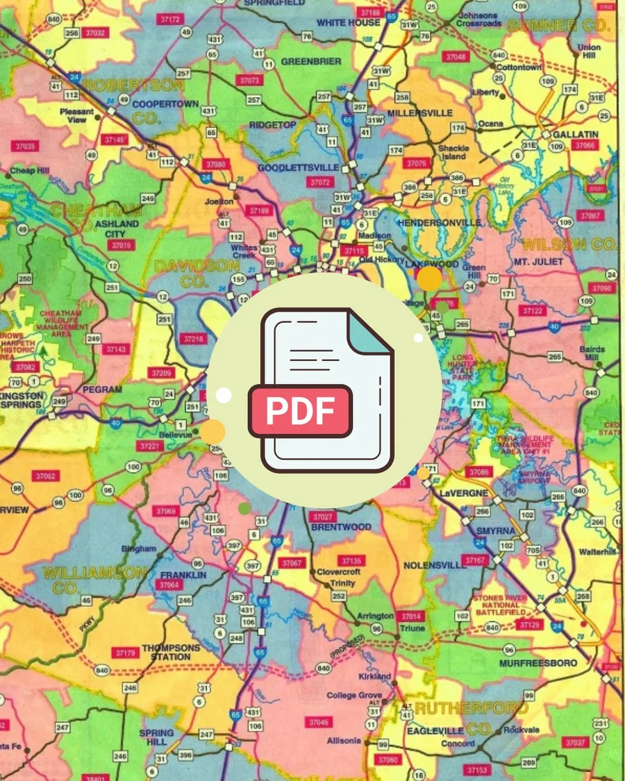
⬅️ ⬅️ Click to Download Our Free Nashville ZIP Code Map
Whether you're buying or selling a home in Nashville, understanding ZIP codes is crucial for your property search. Our comprehensive Nashville ZIP code map covers all five counties in the greater Nashville area, helping you navigate neighborhoods, school districts, and home values with confidence. 🏡
Why ZIP Codes Matter for Nashville Home Buyers 🎯
When searching for homes in Nashville, using ZIP codes as your primary search criteria ensures you won't miss any properties in your desired area. Many Middle Tennessee communities don't have clearly defined boundaries, making ZIP codes the most reliable way to search for homes. 🔍
💡 Pro Tip: Combine ZIP code searches with school zone preferences for the most effective house hunting strategy.
How to Use Nashville ZIP Codes for Home Searching 📊
ZIP codes are your best friend when searching for Nashville real estate. Here's why this approach works better than searching by city name alone:
🎯 Precision: ZIP codes give you exact geographic boundaries, unlike city names which can overlap or be ambiguous.
🏫 School Districts: Many ZIP codes align with specific school zones, making it easier to find homes in your preferred district.
📈 Market Analysis: Real estate trends and home values are often tracked by ZIP code, giving you better market insights.
🚗 Commute Planning: Understanding ZIP code locations helps you estimate commute times to work or other important destinations.
Download Your Free Nashville ZIP Code Map 📥
This comprehensive ZIP code map has been helping Nashville home buyers and sellers for years. Originally sourced from detailed Yellow Pages directories, it remains one of the most accurate and helpful resources available for navigating Middle Tennessee's complex geographic landscape. 📖
🚀 Ready to start your Nashville home search? Use our ZIP code map to identify your target areas, then contact us to begin exploring available properties in your preferred neighborhoods.
Nashville Zip Codes
- 🏡37013 Antioch / Cane Ridge
- 🏡37027 Brentwood (also see Williamson County)
- 🏡37072 Goodlettsville
- 🏡37076 Hermitage
- 🏡37115 Madison
- 🏡37138 Old Hickory
- 🏡37201 Downtown Riverfront / SoBro
- 🏡37203 Music Row / Edgehill / Vandy / West End Circle / Downtown (western) / The Gulch / Wedgewood Houston
- 🏡37204 12 South / Belmont / Lipscomb / Oak Hill / Edgehill / Melrose
- 🏡37205 Belle Meade / West Meade / West Nashville
- 🏡37206 East Nashville / Lockeland Springs
- 🏡37207 North Nashville / Dickerson Pike
- 🏡37208 Germantown / TSU / Salemtown
- 🏡37209 Sylvan Park / Sylvan Heights / The Nations / Charlotte Park
- 🏡37210 Woodbine / Glencliff / Briley / Elm Hill
- 🏡37211 South Nashville/ Whispering Hills / Brentioch / Lenox
- 🏡37212 Music Row / Vanderbilt / Hillsboro Village / Belmont
- 🏡37214 Donelson / Airport
- 🏡37215 Green Hills / Forest Hills / Belle Meade
- 🏡37216 Inglewood
- 🏡37217 Edge-O-Lake / Priest Lake / Briley Parkway
- 🏡37218 Bordeaux
- 🏡37219 Downtown / Central Business District
- 🏡37220 Oak Hill / Crieve Hall
- 🏡37221 Bellevue
Surrounding Areas by County
Williamson County
- 🏡37027 Brentwood
- 🏡37064 Franklin
- 🏡37067 Franklin
- 🏡37069 Franklin
- 🏡37135 Nolensville
- 🏡37014 Arrington
- 🏡37046 College Grove
- 🏡37062 Fairview
- 🏡37179 Thompson's Station
- 🏡37174 Spring Hill
Wilson County
Sumner County
- 🏡37075 Hendersonville
- 🏡37075 Gallatin
- 🏡37066 Gallatin
- 🏡37148 Portland
- 🏡37070 Goodlettsville
- 🏡37072 Goodlettsville
- 🏡37048 Cottontown
- 🏡37188 Whitehouse